


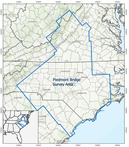
RESTON, Va. — Low-level airplane and helicopter flights are planned over broad regions of North Carolina, South Carolina, Virginia, and West Virginia to image geology using airborne geophysical technology. The airborne survey began in August of 2024 and will continue for approximately one year, weather and wildfire restrictions permitting.
The survey is being coordinated by the U.S. Geological Survey with the goal of providing images that expand the fundamental knowledge of geology across the region. The survey area was chosen due to its both known and suspected mineral occurrences.
Instruments on the airplane will measure variations in the Earth’s magnetic field and natural, low-level radiation created by different rock types beneath vegetation and up to several miles below the surface. This information will help researchers develop geologic maps in three dimensions. Applications include evaluating natural resources such as critical minerals and water, preparing for natural hazards such as earthquakes and radon, and characterizing legacy mining areas.
Flights will cover areas within the following counties:
Virginia: Albemarle, Alleghany, Amelia, Amherst, Appomattox, Augusta, Bath, Bedford, Botetourt, Brunswick, Buena Vista, Buckingham, Campbell, Charlotte, Charlottesville, Covington, Craig, Cumberland, Danville, Fluvanna, Franklin, Goochland, Greene, Halifax, Harrisonburg, Henry, Highland, Lexington, Louisa, Lunenburg, Lynchburg, Madison, Martinsville, Mecklenburg, Nelson, Nottoway, Orange, Patrick, Pittsylvania, Powhatan, Prince Edward, Roanoke, Roanoke City ,Rockbridge, Rockingham, Salem, Staunton, and Waynesboro.
There’s more to this in the current issue of the Times Virginian newspaper. Support local journalism by purchasing the issue at a local newsstand or subscribing at www.timesvirginian.com/subscriber_services to receive the print edition or view the full article in the e-edition version.


Commented
Sorry, there are no recent results for popular commented articles.